This is a map that has taken me forever to create! For no particular reason. This past year has been a little crazy and although I drew a lot, I just couldn’t seem to make any progress on such project.
When December came, it took me by surprise! How could the year be soon over? Where did it go? There were still so many things I wanted to do, including this map.
So, I gave the final push to finish it. I did not want to cary that on and let it sit there, unfinished. I simply had to get it done.
And so I did! And so it is!
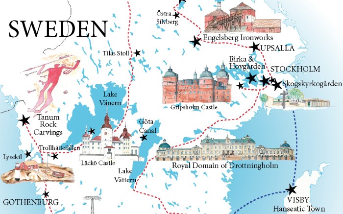
A road trip in Sweden
This map is for a fairly long road trip. Sweden is a vast, vast country and such itinerary doesn’t cover it all, far from it actually! It is focused on the Southern part of the Country. If you look at a full map of Sweden, you’ll realize that only about 1/3 of the country is shown on my map.
Yet, following this itinerary or even part of it, will, I believe, give you a great introduction to this amazing country. And probably a thirst for more!
You can check some of the places I’ve already managed to talk about on RTatW. I will add more.. one day or another.
Obviously, I included all the UNESCO World Heritage sites I could, on such map. You know me! If you don’t, then I’ll just say that UNESCO sites are my thing 😉
Of course, there are a lot of castles too! Again, you know me, right!?! If you don’t, well castles are also my thing!
I hope this map will inspire you to visit Sweden! If you don’t have a lot of time and can’t do the whole road trip, then definitively go to Stockholm and explore its surrounding.
So, here is the map!

You can find the detailed itinerary on RTatW of course. It includes a couple additional places, that are not shown on the map, but which you may want to add to your trip.
There, on RTatW, you will find the link to the high definition version of the map. It is free to download and use. Use for a road trip, not for ‘commercial use’! On RTatW, you’ll also find the individual drawings as postcards, also free to download in high definition (those are however for RTatW newsletter readers).

You learn a lot when blogging
You learn a lot when traveling. Well, when you don’t spend your days sunbathing on a beach, or locked in a resort.
But you also learn a lot when blogging! When you don’t just blog about the pretty dress you wore, I guess.
When working on this map, I used a lot of the research I had done planning my previous trips to Sweden. Yes, I’ve been several times now. And for every place I visited, I’ve put a lot of research in, before and after. So I do learn quite a bit, on a lot of different topics.
Yet, there are times where something very unexpected comes up and this time it was also in an unexpected way!
What is it? Well, its about the lakes in Sweden!
When drawing the map outline for this map, I started by drawing the 2 main lakes and then added the smaller ones. And as I was drawing more and more, I realized it seemed to form a pattern. Most of the lakes I was drawing seemed to be elongated and they kind of all seems to converge to a central point between the 2 main lakes!
Look at the below extract of the map! Do you see it, or am I nuts?
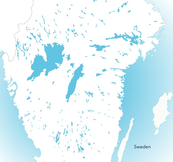
Well, I don’t know for sure yet. My research on the topic haven’t yet been conclusive but in addition to castle architecture, I’m also studying geography now! My former teachers would be so proud!
On to the next map now! I’ve just started so who knows how long it’s going to take me!
Hope you like this one!


